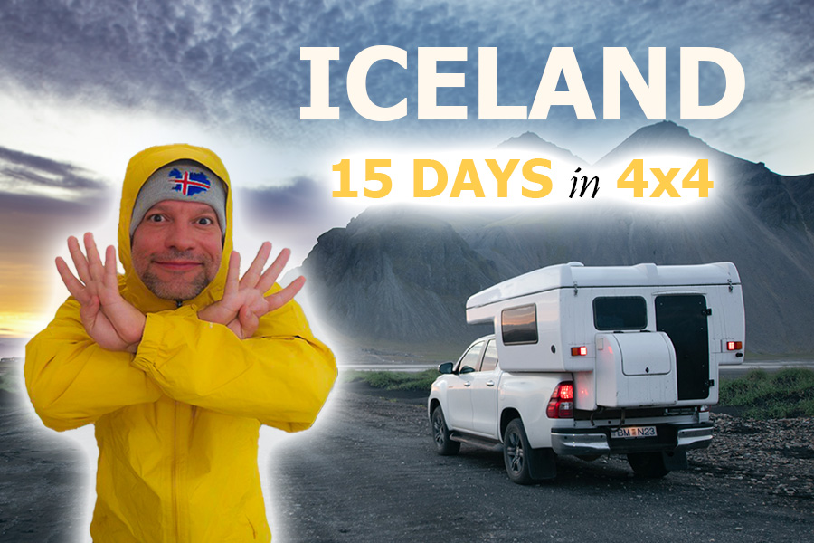


15-DAY 4×4 ROAD TRIP ICELAND ARROUND RING ROAD & HIGHLANDS
◊ ITINERARY TO THE HEART OF THE UNKNOWN ◊
Published 4 SEP 2025
Iceland, one of the most fascinating and beautiful countries on our planet. An island of geysers, glaciers, waterfalls, hot springs, massive volcanoes, and lava deserts. A remarkable place where ice and fire merge to create unforgettable landscapes.
The best way to explore the country is with a 4×4, venturing into its highlands and driving the Ring Road, a circular route that gives access to much of the hidden wonders awaiting in these stunning lands.
That’s why, over 15 days, we embarked on an unforgettable journey, allowing us to discover remote and desolate places. If you’re planning to explore Iceland soon, don’t miss the perfect route we’re about to share.
BEFORE TRAVELLING TO ICELAND IN A 4×4
Ten years later, we decided to return to these lands. Hard to believe, right? A decade after that wonderful 10-day trip around Iceland in a campervan, which allowed us to drive the Ring Road and discover some of the most fascinating landscapes of this incredible island. Back then, our itinerary was limited to the circular route, a restriction you face when travelling Iceland in a regular car, or, as we did, in a campervan.
Because of this, we had to skip many places, such as the Highlands in central Iceland, accessible only by a 4×4. That’s what motivated us to return with the intention of renting a 4×4. A great choice this time! Not only did we revisit the Ring Road and relive those memories from ten years ago, but thanks to our Toyota Hilux, we could also venture into Iceland’s strange and remote Highlands.
After our recent experience, we were able to confirm what we had suspected all along: the true essence of this incredible place lies hidden among the glaciers, volcanoes, and lava deserts that rise from the heart of Iceland.
Beyond the safety and comfort of driving a 4×4, travelling in Iceland with such a vehicle opens up a whole range of possibilities when planning your itinerary.
While many of Iceland’s iconic sights are accessible from the Ring Road, its most unusual attractions lie in the island’s interior. Reaching them requires crossing rivers and driving on gravel and volcanic ash roads, known as “F-roads,” which are exclusively for 4×4 vehicles.
Renting an all-terrain vehicle in Iceland allows for an experience far from the ordinary, giving access to remote places untouched by mass tourism. Without a doubt, it’s the perfect journey for anyone looking to surprise themselves and enjoy nature without limits.
There are two ways to plan a 4×4 trip around Iceland. One is to rent a campervan to stay in campsites, and the other is to hire a conventional 4×4 and book hotels for overnight stays.
4×4 Campervan
In my opinion, this is the best option, as it allows for a flexible itinerary without the need to book hotels or campsites in advance. It’s an excellent choice for nature lovers, letting you wake up beside a glacier, in front of a volcano’s ridge, or beneath a waterfall.
If your budget for travelling to Iceland is tight, this is a great option, as travelling in a campervan helps you avoid the extra costs of hotels and restaurants, which are surprisingly expensive in this country.
Conventional 4×4 Vehicles
This is still a good choice, especially if you’re not used to sleeping in the compact space of a campervan. If you opt for this, you’ll need to plan your route carefully and book accommodations in advance, as the options in some parts of Iceland are very limited.
In Iceland, there are numerous rental companies offering 4×4 vehicles. We always recommend booking with Campervan Iceland, a local agency we’ve trusted since our very first trip in 2015.
They have an extensive fleet of 4×4 vehicles, both campervans and conventional models. If you’re planning a route similar to ours, my advice is to book a vehicle with high suspension and a low-range gearbox, as some models, like the Dacia Duster, are not as safe when crossing deep rivers.
We decided on the automatic Toyota Hilux, with capacity for four people, a vehicle that allowed us to enjoy a wonderful experience under optimal safety conditions. Its performance was excellent at all times, especially when tackling the most challenging sections of our route, crossing rivers and climbing steep gravel slopes.
One of its great advantages is the automatic heating system, which doesn’t require connecting the van to a 220V power supply. It comes equipped with a full kitchen, including a sink, fridge, and utensils, as well as an outdoor stove and a camping table and chair kit.
However, Campervan Iceland also offers more economical options, suitable for two people or larger groups, ranging from jeeps with integrated tents to fully equipped campervans and motorhomes. In this article, we help you choose the best option for you.

If you want to travel to Iceland in a 4×4, it’s likely because you plan to explore the Highlands. It’s important to know that most of the roads leading into the island’s interior are only passable during the summer, usually between mid-June and September, although there’s no exact date, as it depends on the weather. Therefore, if you’re planning a 4×4 trip to Iceland, I recommend going in July or August, which will almost guarantee that no roads are closed.
ITINERARY FOR OUR 15-DAY 4×4 ROUTE THROUGH ICELAND
Our 15-DAY 4X4 ROUTE THROUGH ICELAND was planned to be completed over fifteen full days. Thanks to this incredible adventure, we had the opportunity to explore, in addition to some of the island’s most famous sights like the Golden Circle, the major waterfalls of the South Coast, and Lake Mývatn, much of Iceland’s Highlands. We were able to reach truly remote places such as Landmannalaugar, the Askja caldera, the Kerlingarfjöll mountain range, and the row of craters at Laki (Lakagígar).
15-DAY 4×4 ICELAND ROAD TRIP, DAY 1
On 5 July 2025, we woke up beside Garður Lighthouse, on the southwestern tip of Iceland. After landing at Keflavik Airport, we picked up our Toyota Hilux 4×4 from the Campervan Iceland office. Our first stop was none other than the local Bónus supermarket, a budget-friendly chain that won my trust during my first trip to the country back in 2015.
Once we had stocked up on supplies, we set off towards the first of our many destinations, the Snæfellsnes Peninsula, located about 95 miles north of Reykjavik. Famous for being home to the volcano that inspired Jules Verne’s Journey to the Centre of the Earth, during this first day we explored the southern coast and the western tip of this remarkable region.
We began by relaxing in our first hot spring bath of the trip at the natural pools of Landbrotalaug. Along with the seal colony at Ytri Tunga, the Bjarnafoss waterfall, and the iconic Búðakirkja church, some of the most breathtaking landscapes the peninsula offers are found at the cliffs of Arnarstapi and Lóndrangar.
At the westernmost point, along the road connecting the Saxhóll crater and Skarðsvík beach, we were lucky enough to catch a glimpse of the snow-capped summit of the famous Snæfellsjökull volcano.
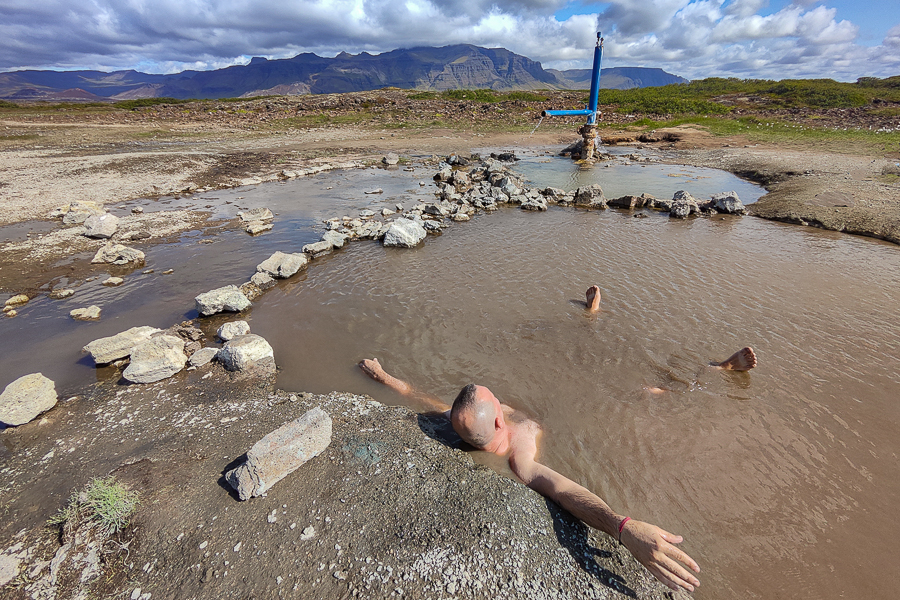
Landbrotalaug
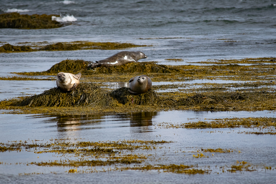
Ytri Tunga

Bjarnafoss
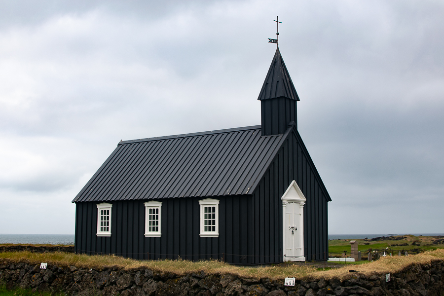
Búðakirkja

Arnastapi
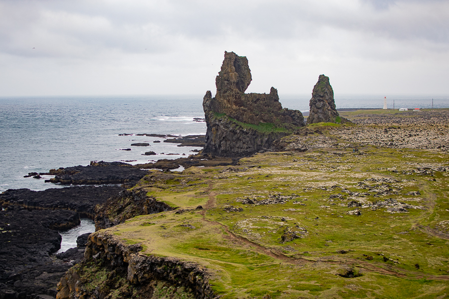
Lóndrangar
Sáxholl

Skarðsvík

Sæfellsnesjökull
15-DAY 4×4 ICELAND ROAD TRIP, DAY 2
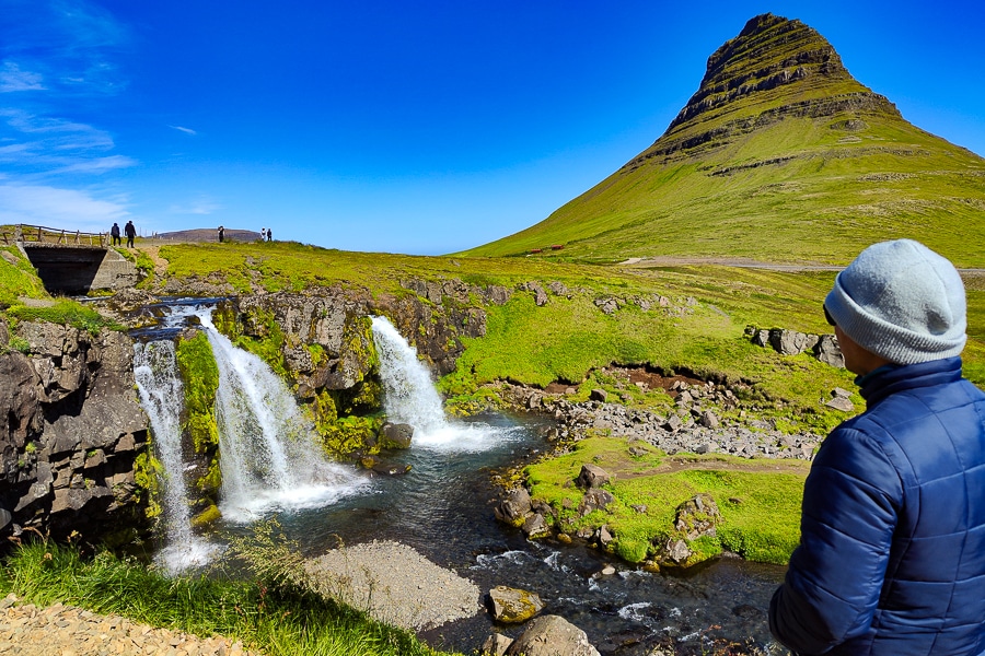
The Snæfellsnes Peninsula is also home to one of Iceland’s most famous waterfalls, Kirkjufellfoss. Its location by the sea, combined with the strikingly conical, almost perfect shape of the mountain behind it, has made it one of the most photographed landscapes in the country. Not far from it lies another beautiful waterfall, Grundarfoss.
However, this was just a prelude to what awaited us next. By the Hvalfjörður fjord, as a grand finale to the start of our journey through Viking lands, we were greeted by Glymur, which, at 650 feet tall, is considered the second-highest waterfall in Iceland.
Kirkjufellfoss

Grundarfoss

Glymur
15-DAY 4×4 ICELAND ROAD TRIP, DAY 3
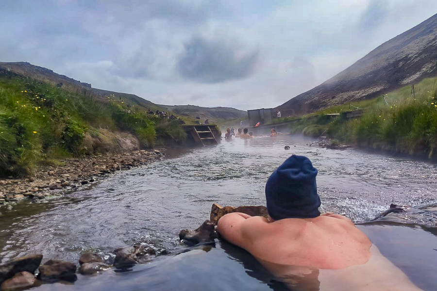
Our journey continued, and the real excitement began as we set out to explore Iceland’s Golden Circle, one of the most visited routes on the island. We started the day enjoying a soak like Vikings in a thermal river, this time choosing the warm waters of Reykjadalur, which you reach by walking through a beautiful valley filled with fumaroles and sulphur deposits.
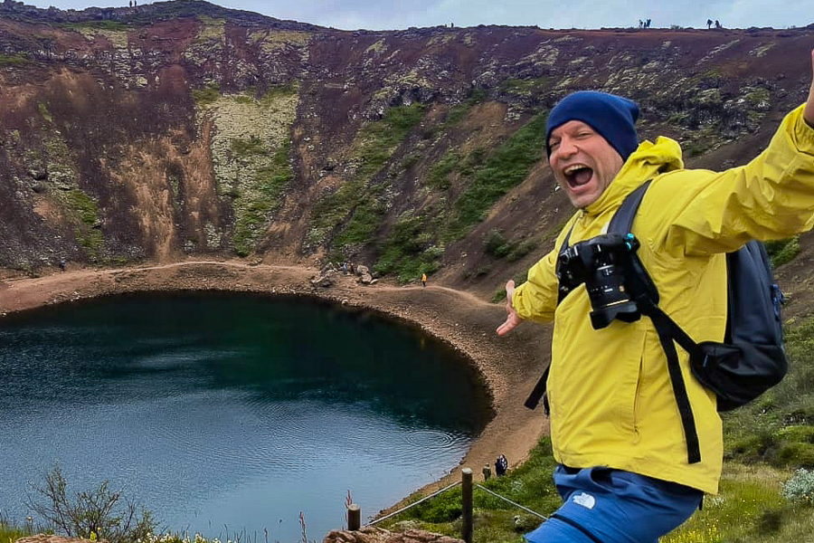
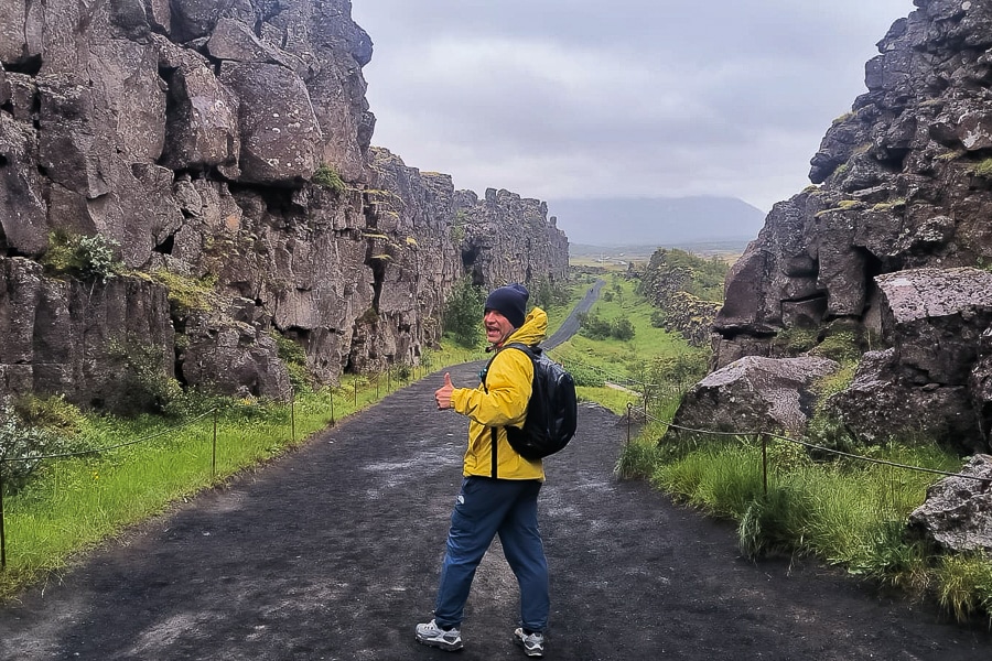
Afterwards, we made a brief stop at the Kerið crater, whose bottom holds a lovely emerald coloured lagoon. This served as a prelude to visiting Þingvellir National Park, a mysterious place split by the fault that separates the North American and Eurasian tectonic plates.
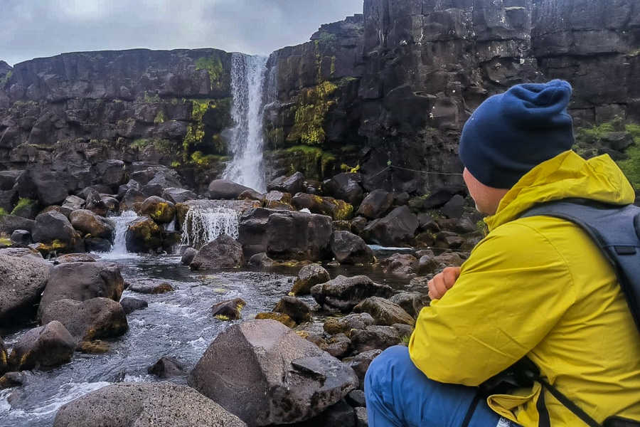
Considered one of Iceland’s most historically significant sites, Þingvellir was where the Alþingi, one of the world’s oldest parliamentary institutions, was founded in 930. In Viking times, Þingvellir was used to judge criminals and execute them by throwing their bodies into the icy waters of the Öxará River, which forms a beautiful waterfall over the cliffs of Almannagjá. Not far from here, just outside the park, is the strikingly blue waterfall of Brúaráfoss.
However, the main attraction of the Golden Circle is the Haukadalur geothermal area, home to Strokkur, the most reliable geyser in the world, which erupts every few minutes. Its boiling water column can reach up to 130 feet in height.
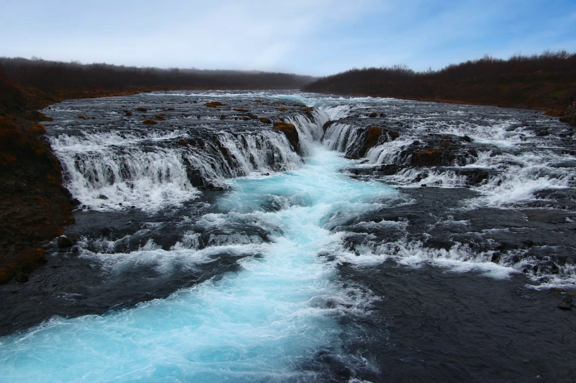
We concluded this wonderful journey through the Golden Circle by visiting the third major waterfall of our trip, one of Iceland’s most famous and awe-inspiring, Gullfoss, whose name means the Golden Waterfall.
Reykjadalur
Kerið
Þingvellir
Öxárarfoss
Brúaráfoss

Strokkur

Gullfoss
15-DAY 4×4 ICELAND ROAD TRIP, DAY 4
It was time to venture into Iceland’s Highlands for the first time. Route 35, Kjölur, is a historic Icelandic road that crosses the island from north to south. Heading into the heart of Iceland and flanking the Langjökull glacier, we passed through some of the most desolate deserts of the Highlands.
Our goal was to reach the Kerlingarfjöll mountain range, a place of magical colours dotted with rhyolite cliffs and geothermal springs. Although we feared that the thick fog might obscure our visit, once again, showing signs of its presence, divinity kindly granted all our wishes. Suddenly, the sky cleared, and the landscape began to offer moments of great wonder.
We ended the day exploring Hveravellir, a beautiful geothermal oasis filled with fumaroles where Mother Earth exhales. The final delightful surprise this fascinating place offered us was its stunning turquoise pool, where we decided to rest and relax peacefully before heading back to civilisation.

Kjöllur Route

Kerlingarfjöll

Hveravellir

Hveravellir Hot Spring
15-DAY 4×4 ICELAND ROAD TRIP, DAY 5
Our plan was to reach the city of Akureyri, also known as the Capital of the North. It was a transition day in which we covered about 220 miles, crossing the island’s northernmost valleys.
Our journey through North Iceland treated us to stunning views of the Arctic, including the surreal sight of the rock formation Hvítserkur, a beautiful petrified dragon seemingly quenching its thirst in a small bay.
Halfway along the route, we came across a lovely waterfall, Reykjafoss, where we took the chance to enjoy a relaxing soak in Fosslaug, a dark-water hot spring pool right next to the river. As I mentioned, Akureyri, resting on the shores of Eyjafjörður fjord, is considered the most important city in northern Iceland. Its calm and peaceful atmosphere quickly drew us in, encouraging us to celebrate late into the night like true Icelanders.

Hvítserkur

Reykjafoss

Fosslaug

Akureyri
15-DAY 4×4 ICELAND ROAD TRIP, DAY 6
What better way to recover from a lively night out than with yet another soak in hot water? Foss, a little-known hot spring pool set in the bed of a crystal-clear stream near the coast of Akureyri, is unique for flowing directly into the Arctic Ocean, forming a beautiful waterfall. Without a doubt, it was one of the most surprising spots of the entire trip.
We needed to recharge our energy before continuing, as one of the most intense days of our route awaited us. We started strong, visiting two of the most famous waterfalls in North Iceland. The first, Aldeyjarfoss, is a stunning cascade plunging between dark basalt columns.
Next came Goðafoss, the Waterfall of the Gods. With its distinctive horseshoe shape and the history surrounding its waters, it’s among the most famous and beautiful in the whole country. It was here, during Iceland’s conversion to Christianity, that the last pagan idols brought from Þingvellir were cast into the falls. A true natural gem that fully recharged our batteries before continuing towards Lake Mývatn.
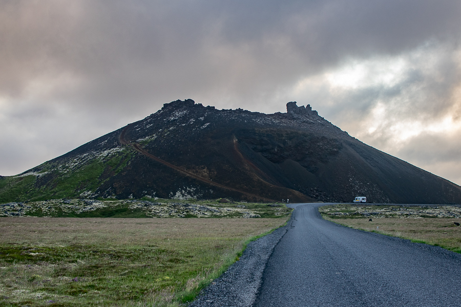
Known as the Pearl of North Iceland, this region sits right on the Mid-Atlantic Ridge. Its volcanic nature has created an astonishing landscape filled with unusual formations, such as the Skútustaðagígar pseudocraters, Dimmuborgir, and volcanic craters like Hverfjall, an almost perfectly circular ring offering views across the far reaches of northern Iceland.
Beyond the volcano lies the wonderful ochre-coloured world of Hverir, a geothermal field of fumaroles, bubbling mud pools, and sulphur vents releasing an intense smell of sulphur and rotten eggs. To wrap up the day, we visited the Víti crater and the Krafla caldera, an extensive fissure zone stretching about 55 miles, still steaming since its last eruption in 1984.
Along the road leading to Krafla, we took our final soak of the day, enjoying a surreal hot-water shower in the middle of nowhere.

Foss

Aldeyjarfoss

Goðafoss

Skutustadagigar & Myvatn Lake

Dimmuborgir

Hverfjall

Hverir
Viti Crater
Krafla
Krafla Shower
15-DAY 4×4 ICELAND ROAD TRIP, DAY 7
After resting by the beautiful Lake Mývatn, we decided to venture into the depths of Grótagjá, a narrow cave that hides a stunning emerald-coloured thermal lagoon. Afterwards, we set course for Jökulsárgljúfur National Park, where we made several memorable stops.
Our first stop was to visit the waterfalls of Selfoss and Dettifoss. The latter, about 330 feet wide with a drop of 150 feet, is considered the most powerful waterfall in Europe. After that, we took a short walk through the Jökulsárgljúfur canyon. Following the western bank of the Jökulsá á Fjöllum River, we reached the beautiful Hafragilsfoss waterfall.
We then headed once again towards the Icelandic Highlands, taking on one of the most challenging routes in the entire country, the road leading to the volcanic Askja caldera. It’s a 62-mile drive across vast lava fields, volcanic ash deserts, and river crossings. The journey took around four hours, made possible by our trusty Toyota Hilux, a true beast of a vehicle that let us enjoy this adventure safely and comfortably, all thanks to Campervan Iceland, our reliable agency in Iceland.
By the early hours, we were circling the rim of Askja crater, one of the most volatile in Iceland, whose floor shelters a beautiful lake reflecting the surrounding mountains.
Grótagjá
Selfoss

Dettifoss

Jökulsárgljúfur River Canyon
Hafragilsfoss

Askja Route

Askja
15-DAY 4×4 ICELAND ROAD TRIP, DAY 8
We made our way back towards the Ring Road, and along the route, we came across Stuðlagil, a stunning canyon of basalt columns whose fame skyrocketed with the rise of social media.
Tucked deep within a narrow fjord, we spent the night in one of Iceland’s most beautiful villages, Seyðisfjörður. The colourful walkway leading to the village church has become one of the country’s most iconic and photographed sights. Just off the road that leads into the fjord, we spotted a lovely waterfall, Gufufoss.
Stuðlagil
Gufufoss
Seyðisfjörður
15-DAY 4×4 ICELAND ROAD TRIP, DAY 9
We started the day by visiting Hengifoss. Surrounded by layers of basalt and red clay, this 420-foot-high waterfall is the third tallest in Iceland. Afterwards, we continued straight along the Ring Road, travelling through the eastern fjords of Iceland until we reached the charming fishing village of Djúpivogur, a journey that rewarded us with postcard-perfect views all along the way. We spent the night at the campsite located beside the Stokksnes Mountains.
Hengifoss
East Fjords
Djúpivogur
15-DAY 4×4 ICELAND ROAD TRIP, DAY 10
Our tenth day exploring Viking lands began in front of the Stokksnes Mountains and their Viking Village. After an unsuccessful attempt the previous night, once again, good fortune smiled upon us, and the weather conditions allowed us to admire the dramatic reflections mirrored on the still waters of this stunning spot.
That experience only heightened our desire to start exploring the southern slopes of Vatnajökull, the largest glacier in Europe. Travelling along the Ring Road, the landscape is dotted with countless glacier tongues descending from the icy fields of this colossal giant, beneath which lie some of Iceland’s most active volcanoes.
One of the most challenging scenic drives in the area is Route F985, which winds along the edge of the Skálafellsjökull glacier. It’s suitable only for confident, experienced drivers. One of the most breathtaking sights on the south coast is undoubtedly the Jökulsárlón Glacier Lagoon, where icebergs drift towards the Atlantic Ocean and wash ashore on the nearby Diamond Beach, creating a surreal, glittering landscape.
Before ending the day, we decided to visit another nearby lagoon, Fjallsárlón, as well as the glacier tongues of Svínafellsjökull and Skaftafellsjökull, the latter located within Skaftafell National Park.
Stokksnes
Viking Village
Skalafellsjökull

Jökulsárlón
Diamond Beach
Fjalsárlón

Svínafellsjökull

Skaftafelljökull
15-DAY 4×4 ICELAND ROAD TRIP, DAY 11
Skaftafell National Park, resting on the glacial slopes of Vatnajökull, is one of Iceland’s most beloved recreation areas, even among locals. Considered a true paradise for hiking enthusiasts, the park offers numerous walking trails for all levels.
From a short stroll to the stunning Svartifoss waterfall, one of the most famous on the south coast, framed by its striking dark basalt columns, to longer hikes that loop around the glacier tongues spilling down from the vast ice fields that blanket Iceland’s interior.
We decided to take on the full Skaftafellsheiði trail, which took us around six hours to complete. In addition to offering breathtaking views of the glaciers that border the park, it also rewards hikers with distant glimpses of Iceland’s highest peak. Another highlight of the route is the view, though from afar, of Morsárfoss, discovered in 2011 and, at 790 feet (240 metres), considered the tallest waterfall in Iceland.
We spent the night in the charming village of Kirkjubæjarklaustur, located west of the park, home to the Stjórnarfoss waterfall. Along the way, we stopped to photograph the famous Foss á Síðu waterfall, a picture-perfect stop along the south coast.
Skaftafellsheiði
Morsárfoss
Svartifoss
Foss á Síðu 
Stjórnarfoss
15-DAY 4×4 ICELAND ROAD TRIP, DAY 12
It was time to make the most of our 4×4, as we ventured once again into Iceland’s Highlands to explore the Lakagígar craters, a dramatic landscape that perfectly illustrates the raw power of Mother Earth.
Before that, we made a short stop to walk along the edge of Fjaðrárgljúfur, a stunning, thousand-year-old canyon located just off the Ring Road.
The Lakagígar route begins between the village of Kirkjubæjarklaustur and the Fjaðrárgljúfur canyon, where a clearly marked junction signals the start of the F206 mountain road. As this is a highland track, a 4×4 vehicle is absolutely essential. After fording the first rivers, we came across the beautiful Fagrifoss waterfall, whose name literally means “the beautiful waterfall.”
After around three hours of driving, we reached the ranger’s hut located beneath the slopes of Mount Laki. A short hike leads to its summit, from where you can admire the line of craters that, back in 1783, tore through the Earth’s crust, spewing lava and ash for over eight months.
The Laki eruption remains one of the most catastrophic events in Iceland’s history, as the toxic cloud that spread across much of Europe wiped out half the country’s livestock and triggered a famine that claimed around 9,000 Icelandic lives. One of the most striking sights is the Tjarnargígur crater, which shelters a stunning emerald-green lagoon at its base.
We ended the day camping in the village of Vík Í Mýrdal, the southernmost settlement in Iceland, reached by crossing the Eldhraun lava field. This vast expanse of moss-covered lava, born from the Laki eruption, now glows with an almost fluorescent green hue, an otherworldly sight that perfectly capped off the day.
Fjaðrárgljúfur
F206
Fagrifoss

Laki
Tjarnargígur
Eldhraun

Vík Í Mýrdal
15-DAY 4×4 ICELAND ROAD TRIP, DAY 13
If there’s one true landmark that defines Iceland’s south coast, it’s the rock formation of Dyrhólaey, a perfect natural arch located beside Kirkjufjara beach. Although the area is currently closed to visitors due to recent rockfalls, we were lucky enough to spot a large colony of puffins from the nearby viewpoint. These charming birds have become one of Iceland’s most beloved national symbols.
Right next to it lies what many consider to be the most beautiful beach on the planet, Reynisfjara. The near-perfect symmetry of its basalt cliffs and the petrified trolls watching over visitors from the waves of the Atlantic Ocean have made it one of Iceland’s most photographed spots.
After visiting the area, we backtracked along the Ring Road heading east to take the F208, a route that, after exploring thoroughly, I can confidently say is the most beautiful road we travelled on. Crossing moss-covered lava fields flanking the Eldgjá volcano, it eventually leads to the Landmannalaugar campsite.
This stunning site of rhyolite mountains and fluorescent-green moss, located on the southern edge of the Highlands, has become a paradise for hiking enthusiasts. We chose to follow the Brennisteinsalda trail, a two-hour hike that climbs between steaming fumaroles to a viewpoint overlooking vast lava fields and the caramel-coloured mountains of the valley.
One of the highlights of this magical place is its natural hot spring, where we treated ourselves to a wonderful thermal bath under the soft light of the midnight sky.
Dyrhólaey
Kirkjufjara
Reynisfjara
F208
Landmannalaugar
Landmannalaugar Hot Spring
15-DAY 4×4 ICELAND ROAD TRIP, DAY 14
Our 15-day 4×4 journey through Iceland was drawing to a close. We said farewell to the Highlands of Iceland as we drove along the northern section of the F208 road, still in awe of its stunning landscapes.
However, we still had a few of the most famous waterfalls of the south coast to visit. Before returning to the Ring Road, we stopped at two beautiful waterfalls: the first, Háifoss, and the second, Hjalparfoss, a small double waterfall cascading between dark basalt rocks.
Next, we explored two of Iceland’s most iconic waterfalls. Seljalandsfoss, famous for the path that allows you to walk behind its curtain of water, and Gljúfrabúi, hidden inside a charming cave lined with a soft carpet of moss.
We enjoyed our final hot spring bath with the same excitement as the very first one in Reykjadalur. This time, we chose the waters of Seljavallalaug, located just before reaching Skógarfoss, Iceland’s most famous waterfall. With its 197-foot (60 m) height and the perfect symmetry of its thick curtain of water, it has been officially named the perfect waterfall.
Háifoss
Hjálparfoss
Seldjalandsfoss
Gljúfrabúi
Seljavallalaug
Skógarfoss
15-DAY 4×4 ICELAND ROAD TRIP, DAY 15
During the morning of our last day in Iceland, we decided to explore part of the trail that, over three days of hiking, leads to the Thórsmörk Valley. Known as Fimmvörðuháls, its first stage follows the right bank of the Skógá River, whose course delights hikers with a total of 22 waterfalls.
The trail begins at the top of Skógarfoss. We decided to walk the first section of this path, where we enjoyed the initial waterfalls of this popular hiking route. If you’re looking for an alternative, you can visit the Sólheimajökull glacier tongue, which I discovered during my first trip in 2015, and even reach the famous crashed plane in southern Iceland.
Before heading to the capital, we also visited Kvernufoss waterfall, easily accessible from the Skógarfoss camping area. We then dedicated the entire afternoon to wandering through the streets of Reykjavik, discovering its charming old town and some of the city’s most curious spots.
Fimmvörðuháls
Kvernufoss
Reykjavik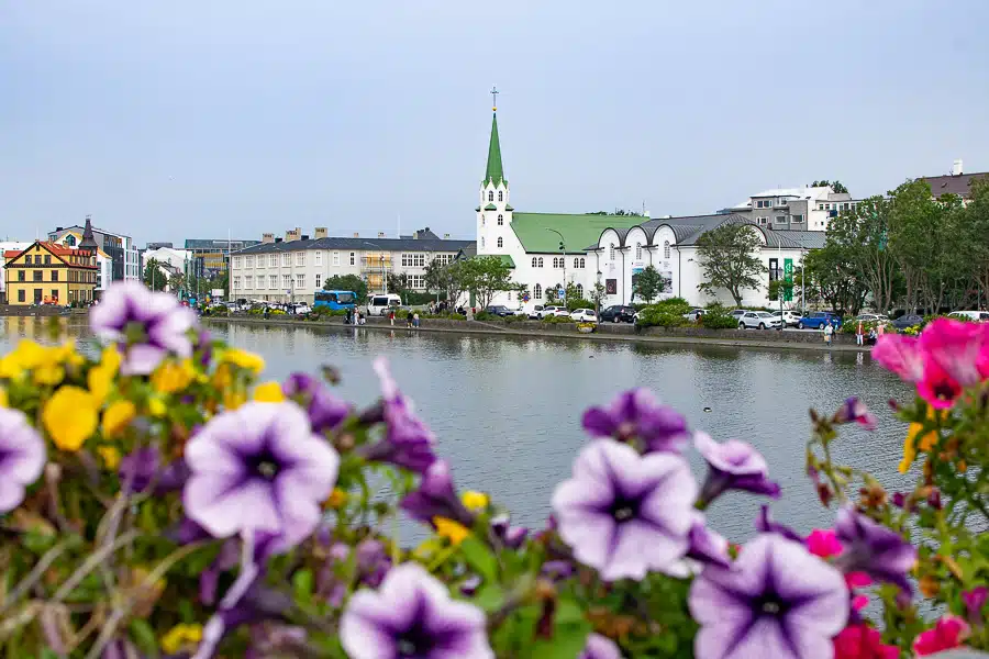
MAP OF OUR 15-DAY 4×4 ROUTE AROUND ICELAND
And before continuing, don’t forget to take a look at the MAP OF OUR 15-DAY 4×4 ROUTE AROUND ICELAND, which will be a great help during the planning and throughout your trip. Remember, you can share it in your Google Maps using the “Share, Embed on my site” option. This way, you’ll have all the locations downloaded in your app, making it easier to navigate once you’re at your destination.

What did you think of today’s article, 15-DAY ICELAND ROAD TRIP IN A 4×4? Comment, share it on your social media, follow our adventures on Instagram, and help us improve.

